Admittedly, my mind has been filled with Taiwan trip and other office stuff in the past few weeks prior to the trip itself and before my mandatory leave. That is, I had to finish all my deliverables in the office and at the same time, ensure that everything about the preparation for the upcoming trip is done.
Yet I won't let my Mt. Kalawitan traverse story, which happened in the last weekend of January this year, left untold. This one, apart from being a major climb, holds a special part in my heart. First, it's a climb in Cordillera. Second, it's a rare climb event. In fact, our guide told us that our group is the the seventh team to do the traverse from Bontoc to Sabangan. Third, it was my intended training climb for Snow Mountain the following month, in terms of trail and cold temparature.
To iterate, I have been eyeing this mountain since 2012 but because I overheard of the costly guideship, I didn't have the guts to make it happen. That was also the year when I climbed Amuyao and Napulauan which I think satisfied me already that time. Now, it's time to go back.
A very limited information on the Mt. Kalawitan traverse is what you will find on the internet, that's why we also had a hard time gathering information in organizing this event. It was Dennis Hisanan still who patiently gathered the details to make the climb possible.
 |
| breathtaking view of mountainous Bontoc/Bayyo rice terraces |
DAY 1 AND START OF THE CLIMB
Similar to the normal way of transportation to Mt. Amuyao's and Napulauan's jump off points, we also took the Banaue-bound Ohayami bus. Upon arrival in Banaue, we were picked up by the chartered jeepney at the terminal.
Here below are some of the stopover/sidetrips while being transferred to the jump off point in Talubin, Bontoc, Mountain Province.
 |
| Behind us is the still majestic Banaue Rice terraces |
 |
| cutie local stuff by Banaue's viewpoint |
 |
| Found an innocent soul at Mt. Polis |
 |
| Welcome to Bayyo Rice Terraces' View Deck! |
 |
| Third time to encounter this motherly Virgin Mary |
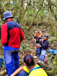
And there came the challenge on getting a guide.
Dennis with the help of the driver had to go down to a village to look for Kuya guide. And the group had to wait too.
We were only able to start the trek by 1pm.
As usual, it is normally hard to get yourself on the mood at the start of the trek especially that majority of the trail is stairways and assault type.
After passing through a village, the next thing is pine forest.
 |
| First "take 10-minute rest" |
 |
| Here is energetic Pong ascending on the trail! |
 |
| Such a lovely day! |
I would say, although this mountain is rarely climbed, the trail is still established, perhaps because of the existence of some hunters.
 |
Just before settling on the first campsite
(here's the point with last water source) |
We arrived at Mona campsite by 3:30pm and settled for our first night stay there.
There are lots of insects and in fact, i was bitten.Well, as always, I am the favourite and the two sides of my face would be badly swollen in the next few days.
DAY 2 AND THE QUEST FOR SUMMIT
We got up early and prepared for the second day of the trek.
 |
| Tent down! |
 |
| Lucky 12 :) |
 |
| The Amazonas :D |
This day would be a long, long trek until summit while targeting Matthew's Garden for lunch. Again, we already had no water source from this day forward until we're done with the climb.
We entered the mossy forest. Still it's almost all assault!
 |
| Add caption |
Since this mountain is not often scaled, there are some parts with no name yet. So, my companions were jokingly saying that this viewdeck should be called "Matelle's Viewpoint." :D (Yes, shamelessly after my name! haha!) Hey, this is not official. But see, it's better to have one. :-P
 |
| Matelle's Viewpoint? Agree or not agree? |
The trail is getting steeper.
 |
| Add caption |
We reached Matthew's Garden and ate our lunch there. It has started to rain a bit by this point. By the way, the name was taken from the name of our guide, Matthew, who was part of the exploration climb made on this mountain.
 |
| relax! |
 |
| Thumbs up, first five (including AJ who took this shot)! |
The next trails are uphills and downhills. So grateful when we reached the ridges-like part as those were the only portions where we experienced rolling ones.
Twas 3:30pm when we finally reached the summit. We immediately set our respective tent. It was an open area and so the windy weather was really felt. We were not also able to have socials during that night.
 |
Buddy Dennis and me <3
(the only photo of mine at summit) |
I wasn't able to sleep well. Our fault? What we brought up was a dome-type tent instead of tadpole one. No choice but to dwell on a not-so-stable, swaying shelter. :D Thank God, we survived the night!
DAY 3: DOWN ON THE OTHER SIDE
The weather didn't improve. It was still windy and to make things worse, add some fog rains. We had to move and prepare for the traverse.
The mossy forest on the other side is awesome -- being dense and greeny! Just like the rich mossy forest of Mt. Napulauan.
We took the unusual trail (according to Kuya Matthew) right after the summit and found there another unnamed field. So we called it, "Dennis' Playground." Agree? Hehe!
 |
| Wooohooo! |
 |
| Add caption |
We had a speedy descent due to its continuous steep, downward trail.
Spotted this one. There's a rainbow always after the rain. :)
We stopped and took some rest in this small hunter's house.
Resuming, we reached the pine forest similar to the typical pine firest of Ugo and Pulag - Akiki trail.
We knew we will be close to Apa campsite as we could see and hear Chico river. That was the next target.
At Apa, we cooked and ate our lunch.
From there, it will only take more than 1 hour to reach the end point. Although we were almost through with the traverse, the trail is a little bit tricky -- there's an irrigation there and we should walk on a narrow cemented path with a cliff/river on the right side. If not paying attention, there's a tendency to fall down and get an accident.
The next thing was awesome. Looking forward to reaching the poblacion of Sabangan town which marks the endpoint of the traverse, we passed through the beautiful rice plantations.
 |
| Add caption |
This one below is a masterpiece of mine :)) "Magtanim ay di biro!" (Planting is not easy!)
The whole descent took us approximately 5-6 hours. The chartered jeepney was waiting for us at the poblacion for pick up. We headed to Baguio City for a 3-hour drive. We opted to go on a ride in Baguio for Manila-bound bus instead of Ohayami bus in Banaue because it's uncertain if we can make it on time on the latter bus' schedule. Unlike in Baguio where there's an absolute trips for 24 hours.
 |
| Amazing Mt. Kalawitan View Point |
It was 10pm when we arrived in Baguio. It was a tiring but another epic and fulfilling Cordillera climb. :)
ITINERARY
DAY 0
2000 Assembly @ Terminal
2200 ETD to Banaue
DAY 1
0730 ETA Banaue (Jeepney Transfer)
0800 Banaue to Bonctoc via Private jeep
0900 ETA Mt Polis Stop Over (Have breakfast and buy Pack lunch)
1000 ETD Bontoc Poblacion (take lunch)
1200 ETA Jump-off/Meet Guide - have lunch
1300 Start Trek
1730 ETA Water Source
1800 ETA Monna Campsite/set camp
DAY 2
0600 Wakeup call (prepare breakfast and pack lunch) breakcamp
0800 Start trek. (Prepare for the 8 hour summit assault) Packed Lunch along trail
1200 Regroup;Lunch on trail Jungle forest at Approx. 2,000 MASL
1300 Resume trek
1400 ETA Sitio Suyo
1500 Mathew’s Garden
1700 ETA Summit/Sunset Viewing/Pitch Tent/Dinner
DAY 3
0500 Wake-up Call / Sunrise Viewing / Breakfast / Break Camp
0700 Start Descent
0715 ETA Dennis Playground
1030 ETA Hunter’s Hut
1130 Pine Forest
1230 ETA Apa Campsite, Sabangan late Lunch (water source available)
1330 Resume Trek
1500 Poblacion, Sabangan
1600 Bontoc to Baguio city or Banaue
2300 Baguio to manila or Banaue to Manila


