Knowing Mt. Halcon for the First Time
So which is which?
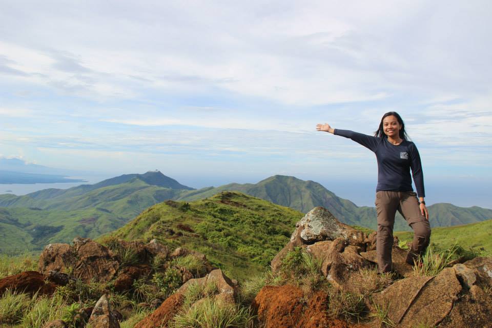
 |
| Knife edge trail approaching the summit of Mt. Halcon, July 2013 |
Then I heard about Mt. Guiting-guiting (G2) which they’ve also claimed as a very technical one.
Late 2012 – I finally got the chance to have my my own experience of G2 traverse. Arriving at the DENR after our descent, we met some DENR people there and I managed to question one of them, “which is harder to climb—G2 or Halcon? He answered, “Technically it’s G2 but mind you, the steps in Halcon are higher than you could ever imagine and it’s a very looong trek.”
As of today --- I had the capacity to compare them and until now, I still really find it hard to assess… then I learned that it depends on various factors and situations. Actually, there are many newly discovered mountains in the country that are currently getting popular and are claimed to be difficult as well and even tagged with a difficulty of 9/9.
Well, how can one assess fairly? As of the moment, I could only tell about G2.. hmmm and also Sicapoo of Ilocos Norte.. of course, this recent Halcon climb that I joined.
On Targeting Mt. Halcon
I wasn’t alone. Obviously, those engaged in this kind of outdoors consciously and unconsciously want their feet to reach such famous diving board-like rock marking the summit of Mt. Halcon.
I was not alone in this pursuit. Having a good conversation with determined fellow ones makes me realized that we are so united on this target.
But this mountain during that time, as mentioned above, was under a climbing ban since 2006 – for the mountains to regenerate and recover as they’ve reasoned out. I heard that others have believed it was closed to cover illegal logging activities. Nobody could testify solidly though some have allegedly shown photos of it.
I became one of them who waited patiently though I waited only for a shorter time compared to them. 2011 and 2012 have passed – no firm news have declared its legal reopening. On the other hand, I was hearing some rumors that others have started to try. Making myself convinced and not too expectant, I had this positive thinking that maybe by 2014, it would be opened again as the local ordinance might have totally expired as well as Mangyan communities might have permitted it finally.
To my surprise, it happened earlier than what I’ve expected. Murmurings in the mountaineering community have started to get louder as it gradually getting obvious that many have started to climb it again. I was in denial at first but the truth is I felt a great urge in my heart to climb it. Hey, this news cracked upon approaching the rainy season. I sticked to my original plan despite Buddy Dennis’ advice that he’ll be joining a group to climb it in July. I was annoyed; it could be a dangerous season restating to myself that I will be climbing it by non-rainy season of 2014 --- until I found myself trapped by the deepest longing of my heart. I clicked JOIN in such a facebook event after the verbal consent of being counted with the available slots. I got IN. No room for backing off. I could even have an issue of getting my leave approved since it was semi-annual reporting period but circumstances favored me.
Having conversation of our group with sir Nic Ocampo after our climb, I learned that it was March 2013 when he got a permit from the authorities to climb it. His formed group was allowed and the rest followed and assumed that it’s already officially open.
Something about Mt. Halcon
Mt. Halcon is one of the reputable and prominent climbs in the Philippine mountaineering. Located in the province of Oriental Mindoro with a height of 2,582+ MASL, it is one of the mountains composing the Knife Edge trilogy of MIMAROPA region (Mindoro, Marinduque, Romblon, Palawan) along with Guiting-guiting in Romblon and Mantalingajan in Palawan. The rich biodiversity, indigenous species and alive wildlife contribute to what this mountain can boast of. This is also a home to the Mangyan tribes and the climbs here are normally accompanied by the native Mangyans. In my opinion, apart from its exotic beauty, varied terrains that you can ever encounter such as major river crossing, rain forest with seemingly has its own weather, higher steps and longer assaults, garnering its highly regarded title can also be traced from those records of fatalities of certain climbers --- hypothermia and drowning in the forceful Dulangan river in 1994 and 2004, respectively. These cases prove that the journey to reaching its top is indeed not easy. In one way or another, one may really suffer depending on his or her capacity and the entire climb should be taken cautiously. Of course, in many minor climbs, deaths and accidents can also happen but this points out too that nature cannot be boastfully defied. Also, one of the highlights of the climb which added to the test is the presence of mountain leeches (limatik) on almost all of the trails. It adds to the test of the climb as you will be facing such kind of trails and at the same time you will be minding on the other side if there’s a limatik sucking on your body and worst to your face.
The Climb Proper
Finishing up with my deliverables..
I was ahead of my deadlines and it was very favorable..
I intended to do it so as I’ll be filing a leave for 2 days..
4 consecutive days to be freed up including the weekend. I succeeded!
I was able to take an undertime on such Thursday and geared up to the challenge of taking MRT transferring to LRT 3 to Tayuman station. Our assembly was 8pm in SM Tayuman as it’s near to where the RORO Bus is. RORO bus is advantageous in a way that we will not mind transferring our backpacks from bus to ferry since such bus itself is part of the cargo.
 |
| the RORO Bus |
 |
| the ferry |
We just went up to the ferry upon arriving and take a short sleep while waiting to finally arrive in Mindoro island in 3 hours. My companions here are Dennis, Rose de Leon, Geronimo Rectum Pable and Kat Ocol and since we know each other in facebook, we all belong to the Middle Team and it was a great thing to be together in this climb. By the way, I learned before the climb and upon planning for meal groups that the whole Halcon climbers that we are, are divided into 3 groups. So each of us probably was expecting that we will be scaling the mountain with such a huge number of participants. Well, still good enough that we’re divided. Moving on, I think we arrived earlier than our itinerary. And here we go, we’re just getting closer to the much awaited ultimate climb. The journey started.
DAY 1: A JOYFUL START OF THE ASCENT WITH ANNOYING DELAYS –
Our first stop was of Sir Nic’s house who is the contact person of our organizers. We left some of our things that we will use going back to Manila. Honestly, we were a bit delayed since everybody, based on the presented itinerary, was expecting to start as early as 4:30am. But it was still acceptable since such kind of delays normally happens. We were transferred though a chartered jeepney and arrived at Lantuyan jump-off point at around 7am but after some sort of negotiations with the Mangyans, our organizers have informed us that there was a disagreement with the ratio of porter to the participants explaining that their decision was not to tolerate the stand of the Mangyans there. Ending up with the decision to take another trail, we moved on. The alternative trail, according to them, is a bit longer trek compared to Lantuyan. Afterwards, there was a little sort of transferring from one jeepney to another which I didn’t mind questioning why it had to be that way (new jeepneys to transport us that were getting smaller and smaller). It should be tolerable especially for the eager "me" to finally start the trek… but it was also stressful and tiring. .. Imagine transferring our weighty things from one jeepney to another.
 |
| at Lantuyan jump off point |
While travelling through the jeepney, we spotted the entirety of the Mt. Halcon in Baco, Oriental Mindoro and it added “more itchy to climb it” feeling to my feet. Whew, I couldn’t wait anymore for us to alight at the jump off point.
 |
| Mt. Halcon (Sialdang).. here we come! |
 |
| Prayer before starting the trek |
Assault.. assault.. chasing the breath.. take 5.. the usual pag-ahon..

Our first long stop was at Iglesia Ebanghelika of Mangyans where we took our lunch and enjoyed the sweet buko costing Php10 each.

More slopes were encountered by us and we started to face the attacks of lingering limatik. By the way according to guide those brown/black ones are mostly the blood-sucking while the tiger-like/striped ones seem to be attracted only to sweat. Hmmm, perhaps that's why eight limatiks attacked my sweaty face during the trek.
The rains poured over us so we shed ourselves in a small hut (still of Mangyan community).


We regrouped there until noticed that the rains had already stopped and almost all of us arrived. I must be talking too much with the fellows until we were informed by the organizers that we had to take an emergency camp (e-camp) for the benefit of those who need some recovery and rest but we had to wake up as early as 2am to make up for the lost time of trek and delays. We obeyed and trusted them as they also told us that in a few minutes from there, we will be entering the forest already and we need more time and energy to arrive at the target camp. E-camp area there is very rare, they said.

Gladly we pitched our tents and settled at the grassland there overlooking the sea. We were not too high in terms of elevation but the sight of the towns was already good from there. That was only around 3pm and it was easy to set camp and prepare our food for the next day. Three or four of us from the middle group have gathered accidentally and noticed the great amount of delays that we had. We were hopeful though and swore that on the next day, we would be really making up for the delays and double our time to follow the itinerary and reach the target summit. We opted to sleep early instead of wait for the hosted meal (dinner) to serve, so we just settled for some remaining food from our lunch. We had to save our energy for the next day.
 |
| sunset view at Ayambukog (Photo credit: Cheng Santos) |
DAY 2: THE GREAT SCHISM - A GREATER TEST ON QUEST FOR THE SUMMIT
The 2am or 3am plan didn’t happen and we only managed to start the night trek by 4:30 am. We passed by a number of assault-type trails, slippery trail, muddy and rooty ones, a bit swampy and some are with holes. Thankfully, it was dawn and everyone’s mind was to get going. We had a favorable pacing at first.
As for me and buddy Dennis, we had a two-way radio for communication and we understand that we’ll be parting our ways throughout the trek as our plan was me getting ahead of him and save the space of the camp site (strategizing!). I was even the one who brought the tent (ampf! I was annoyed, hehe). And since I was the one who loved the ascending trails, I made sure that I found my momentum and never get sleepy so I just continued my trek and followed my pacing, only to find out that I became the tail of Rose de Leon who belong to the lead team. Just like what Rose and I do whenever we met on the trail, nonstop chit chats followed and again, it was a great strategy to forget the tiring trek and assault (of course I was still mindful of what I am stepping to).


We arrived at Aplaya (the supposed to be camp site for us in our first day) at 9:30am; I guess, being me as the tail of the lead team. Somebody after me said that the others after him/her were far already so the regroup was decided to be in Dulangan river where we can also take our lunch. From Aplaya is a long descent, so it was great that the pacing, which started to slow down approaching Aplaya, had recovered and became better.
Arriving at our next stop, we were wowed by such mighty river Dulangan. Even before our feet touched the rocky side of it, I expedited myself so that I would be able to take pictures and take a bath. It was so green.. so calm.. so beautiful! We arrived there 30minutes after the first of the team reached it. I stopped for a while--- “what’s the day today? Today is Saturday and I should have been at the office for overtime today but here I am in the center of the wilds.. in an awesome forest.. being cradled by Mt. Halcon as I journey to his summit! I am in this beautiful Dulangan river!" Some of us were joking that even though it’s so beautiful, no one would dare to take their prenuptial as getting there is more than a great challenge to the couple and to the photographers especially if non-mountaineers.


As we progress our number there, our lead decided to forward and cross the river as we are more than one and a half hours already there and comsidering we’re making up for the yesterday’s delays. However, I could see no Mangyan guides and porters around. Our companions told that they were in Aplaya and they seemed to give up on the heavy loads they have. Hours passed and they didn’t moved. We didn’t know if they are still planning to proceed.
Full of sweat he answered,”pahinga muna ako.”
Kat also arrived, I told her that our target just like what we've agreed the previous day is summit as much as possible. Then I started to follow Rose and the others who proceeded already. After crossing the river,rocky side of the river and finally, the monkey bridge, they were there waiting and so I joined them waiting for the others and had some sightseeing over the lagoon.

Then it happened…
It started to rain. We started to move. The lead decided to wait at Balugbog Baboy peak. The two-way radio, oh the two way radio—I was keeping on repeating to Buddy Dennis to cross before the river gets wild and our destination where we could wait, “Balugbog Baboy” but it seemed he didn’t get it and all I heard from him was an instruction to turn off the radio as it was raining. Then I heard nothing from him. He turned it off. We kept on trekking. Maybe it was the urgency that the “getting heavy” rains bring that increased our pace. At a blink of an eye, we’re in Balugbong Baboy and it was still raining so hard. We stopped there until decided to resume as we couldn't find some shed there. As for me, I could not tolerate the great and thick pouring of the rain to my body.
 |
| Power 8 at Balugbog Baboy (Photo credit: Bry Briones) |
All of us agreed to resume and pursue summit assault. The questions: Tent? Check! Emergency food? Check! Stove? Check! Cookset? Check! Majority of these things were from self-contained, sir Bry Briones. My contribution: Tent and one canned emergency good. I left one more canned good for lunch the next day, just in case.
Besides, the original plan for the Day 2 was summit assault or Camp 3 the least. We knew we’ll be meeting them there. It’s either they were able to cross the river before the heavy rains or after the river has calmed, they could resume and follow us.
If someone will ask me why I left Buddy Dennis, my answer is this: with no hesitation, my decision is to resume and be with my companions who were the lead and therefore could assist me if ever I would not be able to tolerate the coldness. For me, it was better to save myself and not become a liability than to wait but unaware if they were able to follow or should they managed to follow and crossed the river, then how long will the shivering me could wait?
To be honest, I was positive that buddy Dennis and the rest of the group are safe. I was questioning and appeared worrying but the truth was, I was not. I knew Buddy Dennis could make it.
We were eight. And Yes, our pacing was sustained at the height of heavy rains. We spotted the flow of water along the trail, it seemed like an angry brownish force. It was an unusual rain. And it lasted for around two hours. Even after crossing the Mag-asawang Ilog (a major river stemming or dividing into two), it was still raining hard and thankful the river was still passable and we’re safe. We only noticed that the rain stopped as we progress ourselves to the assault. This time, it was not the rain that hinders and challenges us, it was the trail.
That was the moment when I could see it for myself. It was a very long and nonstop assault. It was not my first time to encounter such kind of trails and I was even expecting for this but since I had to save up my trail food and emergency food, I lose some energy. Carrying a load with such state of “body easily burning the food in-take" wasn't easy. By the way, you may noticed that I was carrying a dayhike backpack but it contained a lot of my necessities including the tent.
The lead team was amazing. It seems I was the only one in the group requesting for just even a take 2 minute-rest. Hehe. And I honor them for the team work they have demonstrated. Sir Dan even volunteered to become the sweeper for us so that we won’t be left behind.
The lead team was amazing. It seems I was the only one in the group requesting for just even a take 2 minute-rest. Hehe. And I honor them for the team work they have demonstrated. Sir Dan even volunteered to become the sweeper for us so that we won’t be left behind.
I told sir Dan in the middle of suffering of carrying such heavy backpack in a continuous assault (approximately 70 to 80 degrees straight). “mas mahirap ‘to sir kesa Mt. Sicapoo sa Ilocos. Ang haba ng assault nito! Para kong nakaharap sa walang katapusang pader! hehe (it’s harder than Mt. Sicapoo in Ilocos, it’s a longer assault. It’s like I’m facing and climbing a wall)” Again, perhaps it depends on the situation: backpack loads,weather, itinerary, etc. They said Sicapoo is much longer. The only difference is, if you take the 3-day itinerary of it (Sicapoo), your day 2 which is summit assault would be a dayhike carrying only an assault pack.
We met the PLDT group who were on their way down. I requested them to relay my message to buddy Dennis that the radio has been turned off already.
We met the PLDT group who were on their way down. I requested them to relay my message to buddy Dennis that the radio has been turned off already.
We changed our clothes and make ourselves dry at camp 3 (Camp Karawayan) before resuming. It was raining from time to time. My knee was challenged. Because of higher steps and since I could not lift myself easily, I sometimes relied on my knee, let it be pointed hard just to parallel my climbing move with the trail.
We finally arrived at Lawian camp, it’s already close to the summit ridge; approximately 45minutes away from the summit, but we decided to set camp already as the ladder in the summit, according to them, might be dangerous or a bit not stable especially if climbing in the dark.
I didn’t mind eating a proper dinner. Sleep and rest were my priorities. I just ate some of my trail food after pitching the tent, changing clothes and making myself dry. Inside my tent was me, Rose, Sir Myk and Ma’am Risa.
It was cold. I knocked myself out and closed my eyes with a hopeful prayer. Hoping for the best.
DAY 3: ONE BLESSED DAY
Thankfully, since our slumber last night, the sky was already calm and stayed calm the whole night. It was cold but tolerable, thankful it didn't further rain for the night. We woke up at 4:00am and alerted by 4:30am. We should be starting to move for the summit and be there before the crack of dawn. Sir Bry cooked a coffee (matabang na coffee kasi tipid hehe) for us but enough to warm us before the assault. Led by Sir Dan, we had a powerful prayer before our summit assault. It moved me and again hoped for the best. By 5am, we proceeded to the main purpose of the day passing by the mini forest and finally the summit knife edge ridge.

We were ascending through the woody ladder when the sun had its half glimpsing and partial rising. And behold! There were no strong winds at all. It was sooo calm at the top and during the trek up to the summit. We were so geared up for the expected cold winds that may threaten us (reminding ourselves of what happened to the hypothermia case of death of Neptali). I felt blessed. Few steps before the real arrival to the top. We offered a prayer over the tombstone marker of Neptali, the exact location when hypothermia hit him and cause another record of death in Mt. Halcon. Sir Dan was right in his utterance of prayers that such fateful day happened to remind us of the risk of this mountain and serve us aide memoire that indeed mountain climbing is to be taken as a risky endeavor. He might be the one who bore the sacrifice by setting a concrete lesson for us, the mountaineers.
 |
| The ladder: on our way up to the summit |
 |
| Neptali's tombstone marker |
And the long wait is over!
I could turn around and dance at the top.
There was no wind but it’s still cold.
Calm sky.
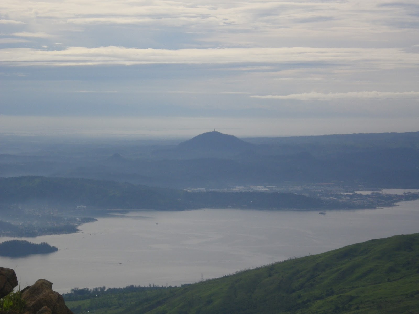
360-degree view.


Facing the eastern part of the are the silhouettes of Mt. Banahaw, Mt. Maculot, Malipunyo range and a part of Quezon and Batangas provinces as well the Oriental Mindoro towns and the coastal areas.
 |
| Mt.Banahaw |
 |
| Mt. Maculot |
At my back (western side) was a mountainous view which reminds me of our Amuyao traverse last year and mountains in Benguet.


And to the south, they said it’s the Paitan trail which is really like a dragon trail. I was amused. I think that was harder compared to what we’ve gone through.

Finally, I won’t forgive myself if I had this chance and missed the diving board-like rock edge facing the east of this mountain top. So that is the famous one marking the summit of Mt. Halcon. This is what most Halcon aspirants enthusiastically go for.
At last!
 |
| Photo credit: Rose Chan de Leon |
After a lot of photo taking, it’s time to bid good bye and have our descent. Target: go back to Camp 1, the Aplaya base camp
.
.
We allotted some time to take a nap and pack our things. Thank God for the sun that we were able to dry our clothes.
We ate breakfast and such simple moment was a memorable and significant one for the rest of my life. We had a limited food supply, remember? So imagine one small cookset for our rice, one tetra pack of beef and beans, one small tetra pack of white tuna, and one small can of corned tuna. Thankfully, they well fed and served the eight of us. Every time I recalled that moment, I knew what to do when I’m finally back to the plains and have my usual breakfast. Yes, there’s no room for wasting food because you will never know the pitiful feeling of those who have nothing to eat. Nevertheless, we were very grateful for such provision. We just survived one meal. :) Thanks sir Bry for preparing our food and for those who have contributed for our breakfast.

During our break camp, we heard some rustling sound from below. Woooh! it was sir Geronimo and Doc Mel! And after around thirty minutes, I heard buddy Dennis shouting and the other two companions and I jumped for joy. I told him I would be teasing him if he wasn't able to make it and that means he had to go back again. (of course this is a joke and I really prayed for his safety.) But for being able to make it, he just completed the Knife edge trilogy of MIMAROPA being Mt. Halcon as his final destination among the three. Congrats Buddy!

By the way, the top was already foggy during their way up but the weather was still good.
Past 9am when we left the Lawian camp and few minutes was camp 3. There we found the other organizer who was the companion of Dennis. He said they stayed overnight at Mag-asawang Ilog and bore the coldness of the night. They tried to follow and stop us, according to them but they were not able to meet us. As for Sir Geronimo, he just tried to follow the first one who proceeded since he was self contained and he felt that his assistance to the other would be a good step.
Meanwhile, everyone was wondering and questioning each other where in this world have our food supply gone. Why we fell short of food?
We took some rice and Ulalam packs for our lunch.
I nearly had a sprain during the steep descending. My backpack seemed to push me down with more force and the muddy trail was getting muddier and muddier. Thanks to sir Dan for saving me when he got my tent out of my bag and bore the burden of carrying it. After a few minutes, it was Rose who sprained her ankle. After that, more cautions in trekking have been applied by us this time, afraid that it might get worse. Although our speed were decreased, according to the lead companions, our pacing was still tolerable.
Almost 6 or 7 hours of descending and we arrived at the target camp site. But before that, another blessed moment was what we've experienced. A short stop after crossing Dulangan River and few steps ascending from it, it rained hard again. Just like the moment when eight of us managed to cross the monkey bridge before the heavy rains on our way up to Camp 2 and Balugbog Baboy. I felt like being cradled and supported by Mt. Halcon. I felt embraced and loved. I felt God’s compassionate ways and mercy. I was safe. We were safe.
 |
| just crossed the Dulangan river and prepared for the last assault for Camp 1 |
And there’s something wonderful amidst every rain or storm. Look at these astounding falls after the rain!
 |
| Photo credit: Cheng Santos (who's also in this photo) |
The rest of the group was waiting there. They said due to the weather situation and deficiency in communication, they were not able/allowed to proceed to the summit.
3 hours later, I saw links of lights coming and it was Dennis and the companions. Thank God they’re safe.
We set camp and it was raining the whole night. We deserved a good rest but unfortunately I didn't get the rest I was expecting. We pitched the tent on the wrong area and it was like lying in a water bed the whole night.
The rest were planning to extend their stay and go for summit attempt the next day.
DAY 4: BIDDING GOODBYE
It was raining when we got up but the weather still improved at around 8am. Some were planning to ascend. Some were packing to descend. Everybody’s busy accordingly.
For us who belong to those who’ll be going down, we prepared our food for breakfast and packed lunch. We had our things, repacked and also had them dried under the sun.
9am when the others pursued the summit on attempt of dayhike while the rest of us started the trek back to the jump off point. It’s the usual descent but one thing I noticed was that I never thought that those were the trails we’ve passed during the night trek as steep areas were of course so visible this time.
We passed by a number of falls and by lunch time, it rained hard again .We just noticed that the rain is normal. For the 4 consecutive days that we were there, it was always true that the rain comes after lunch. I was a little impatient because I could glimpse the town proper but we never arrived very soon at Ayambukog (the grassland campsite where we set camp in our Day 1). While we're descending, Rose and I got the chance to have a small talk with the Mangyan guide, I learned from him that Mayabig trail is partially under Iraya tribe and partially of Alangan tribe of Mangyans. The rest of the trails based from what I've heard was handled by Alangan alone.
Finally, our feet touched Ayambukog. Although it’s only around one and a half hours away from there to jump off point but that’s the time I had a lot of slides and “catching the frog moment.” The trail seemed to be deformed and slippery. So near yet so far because of this trail challenge. |
| The group before parting their ways (Photo credit: Cheng Santos) |
We passed by a number of falls and by lunch time, it rained hard again .We just noticed that the rain is normal. For the 4 consecutive days that we were there, it was always true that the rain comes after lunch. I was a little impatient because I could glimpse the town proper but we never arrived very soon at Ayambukog (the grassland campsite where we set camp in our Day 1). While we're descending, Rose and I got the chance to have a small talk with the Mangyan guide, I learned from him that Mayabig trail is partially under Iraya tribe and partially of Alangan tribe of Mangyans. The rest of the trails based from what I've heard was handled by Alangan alone.
We arrived at the jump off point and directly had wash up at the river there. WOOOOOOH!
After meeting up with Sir Dominic and told him what happened to us and to the others, we ate our dinner.. We had a rainy transfer to the port and arrived there so wet and soaking. (Wishing we could have just asked the driver to take us to the port with his jeepney and we won't mind adding a small amount out of our pockets. But I just couldn't believe it's not included in the climb package just to consider the convenience/welfare of the participants). We had a mini post climb at the ferry . Yes the thirteen of us-- reminiscing the moments.. expressing our complaints..
At 1am we’re already in Batangas. Another tiring yet memorable climb! Successful and Safe..
Few Insights
Everything has a reason. Everything has a purpose. Every happening brings a good lesson.1. I think for a serious major climb, climbing in a huge number is not advisable. The welfare of each participant should be the no. 1 priority. Isn’t it more fulfilling to have the all the participants of the group successfully reached the summit safe and sound? Isn’t it more manageable to have lesser participants where you can easily cater all their needs? One more thing I guess is to also have low impact on the mountain.
2. Communication at all times. Decisions are to be made firm and must be effectively implemented.
3. Hosting the meal for a large group is rarely being implemented successfully. Feeding a crowd is not easy, admit it. Unless you put a lot of effort and be responsible enough with what have been promised in the package. It will never be true.
4. There are always an advantage for being self-contained. You’ll never know what can happen. Prepare for the worst but hope for the best.
5. Know your capacity, do not underestimate a mountain and be sensitive to the needs of others.
6. Prayer is the most powerful and there's nothing wrong with humbling one's self by asking for the guidance of the Higher Being. Expectant faith, that’s it!
It cannot be hidden. Obviously, there were lots of deficiencies, not only due to circumstances, not only on the part of the organizers, not only on each of the participant.. yet I believe, these deficiencies must bring lessons to everyone involved. Again, this happened for us to learn and straighten the mistakes.
Let us still be thankful on the new realizations, be grateful for the protection and safety we got from this nurturing mountain and protection from Above. It was also saddening to hear the hardship and sufferings the rest of companions have experienced in their summit attempt on the fourth day that one of them was even hospitalized. Great thing was, they were safe though.
Memories to keep. Lessons from the past mistakes. Realizations from the Mangyan’s status of life. Friendships for keeps and retained despite what happened. Relationships that needs not be damaged but just to be taken to a peaceful reconciliation. Decision makings to be firmed.--- these were the tests given by Mt. Halcon
My successful pursuit of this prestigious mountain was a great fulfillment for me that I could say “Quota na ko for the year!” hehehe. After years of waiting for this to reopen, I am more than happy to say that I was so blessed to be able to finally reach this sacred mountain and witness its astounding beauty.
*UPDATE as of May 2014: After the mountain has been closed early this year, many Halcon climb events have been observed to happen and push through indicating that it is already open again to the public/mountaineers. Just make sure that necessary climbing requirements and permits are secured. May you have a wonderful Halcon experience in your next climb. Keep safe, fellows!
*UPDATE as of May 2014: After the mountain has been closed early this year, many Halcon climb events have been observed to happen and push through indicating that it is already open again to the public/mountaineers. Just make sure that necessary climbing requirements and permits are secured. May you have a wonderful Halcon experience in your next climb. Keep safe, fellows!